The Golden Baie project is the Company’s flagship precious metals exploration asset. Canstar holds 625 km2 of claims along the Day Cove Thrust and an additional 32 km2 of claims along the Hermitage Flexure in south-central Newfoundland. This large claim package covers favourable geology along a major gold-bearing structure at the eastern and southern edges of the Exploits Subzone, which hosts a large number of the gold deposits and recent new gold discoveries in Newfoundland.
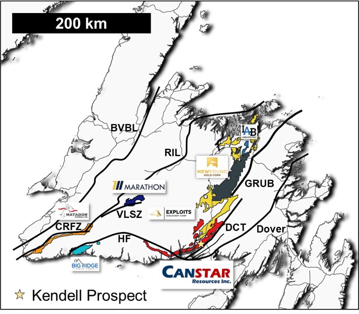 Figure 1 – Location of the Golden Baie claims (red polygon) along the Day Cove Thrust (DCT) and Hermitage Project claims along the Hermitage Flexure (HF)
Golden Baie is typical of productive Paleozoic orogenic gold deposits worldwide. The project displays a strong association of free gold in quartz-carbonate veins or with disseminated sulphides in sheared wall rock argillite or volcanic rocks with an affiliation towards pyrite-arsenopyrite and antimony- (+/- lead, bismuth) sulphides.
Regionally, crustal-scale fault zones throughout central Newfoundland are proving to be significant gold-mineralized structures: e.g. Victoria Lake shear zone and Rogerson Lake structural corridor (Marathon Gold Corp.’s Valentine Lake gold deposits); Cape Ray fault zone (Matador Mining Ltd.’s Cape Ray gold deposits); and the Dog Bay Line-Gander River Complex line (New Found Gold Corp.’s Queensway gold project).
History
Exploration has been both sporadic and limited on the Golden Baie project over the past 40 years, with the last program finishing up over 10 years ago. The project area had seen no modern geophysics and only piecemeal soil and silt geochemistry. Westfield Minerals Limited drilled approximately 60 shallow holes in the region in the 1980s and Mountain Lake Minerals Inc. drilled approximately 50 shallow holes from 2009 to 2011, of which 38 occur on the property. Some of the historic drill holes intersected gold mineralization, such as hole DDH LR-09-02 which intersected 4.8 g/t Au over 3.0 metres starting at 3.5 metres down hole. However, these exploration programs appear to have missed the multiple occurrences of visible gold in outcrops on the claims (Table 1).
Prospecting at the Golden Baie project between 2018 and 2020 by the arm’s length vendors of the claims resulted in the discovery of several new gold occurrences in bedrock with multiple grab samples containing coarse free gold occurring in quartz veins in an area with limited historic drilling. Samples collected assayed as high as 2,213 g/t gold (sample 2019-33) and the re-assay of the associated rock pulp returned 4,485 g/t gold (sample 2019-33 (a)). Other rock grab samples reported by the vendors near this location assayed 1,199 g/t gold (sample 2019-34) and 471 g/t gold (sample 2019-35). All samples were reportedly of argillite-hosted quartz veins (Figure 2).
Table 1 - 2018 & 2019 Assay Highlights (Source: Unpublished reports from Kendell & Northcott, 2020)
| Sample ID |
Source |
UTM Easting |
UTM Northing |
Au (ppb) |
Comments |
| 2019-33 (A) |
Outcrop |
596832 |
5297889 |
4,485,400 |
pulp re-run of 2019-33 |
| 2019-33 |
Outcrop |
596832 |
5297889 |
2,213,867 |
|
| 2019-34 |
Float |
596829 |
5297888 |
1,198,620 |
|
| 2019-34 (A) |
Float |
596829 |
5297888 |
1,073,100 |
pulp re-run of 2019-34 |
| 2019-35 |
Outcrop |
596833 |
5297891 |
471,338 |
|
| 2019-35 (A) |
Outcrop |
596833 |
5297891 |
395,684 |
pulp re-run of 2019-35 |
| LRCN18-12 |
Float |
596685 |
5298097 |
33,377 |
|
| LRCN18-09 |
Outcrop |
598964 |
5301057 |
30,623 |
|
| 64296 |
Float |
596764 |
5298307 |
23,700 |
|
| LRCN18-13 |
Float |
596685 |
5298082 |
20,150 |
|
| LRCN18-10 |
Outcrop |
598956 |
5301061 |
18,787 |
|
| LRCN18-01 |
Float |
599195 |
5301279 |
16,732 |
|
| 373374 |
Outcrop |
596809 |
5297889 |
12,080 |
|
| 2019-07 |
Float |
596701 |
5298184 |
11,814 |
|
| 2019-10 |
Float |
597297 |
5299085 |
10,846 |
|
| CN-41-18 |
Float |
597960 |
5298927 |
10,373 |
|
Note: the reader is cautioned that rock grab samples are selective by nature and values reported may not represent the true grade or style of mineralization across the property.
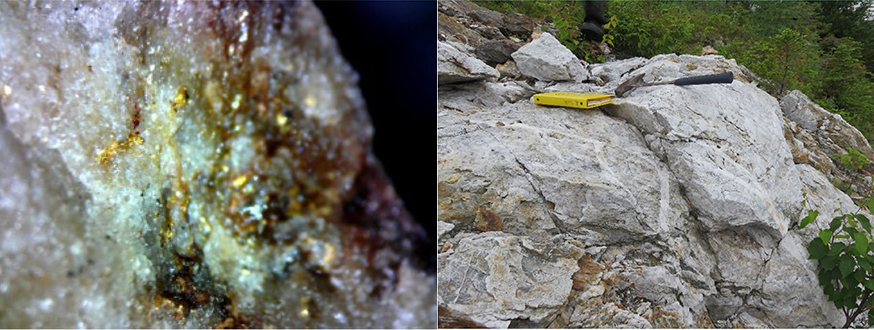 Figure 2 - Multi-generational quartz veining and silicification of argilite host rock (left) and visible gold in quartz (right) from Kendell prospect, Golden Baie
Location and Access
The Golden Baie Project lies within the Coast of Bays region of south-central Newfoundland. Access is provided by Route 360, a paved highway which bisects the project area (Figure 3), and by recent power line and old forest resource roads. More remote areas can be accessed by helicopter while coastal sections can be accessed by boat from St. Albans or Conne River.
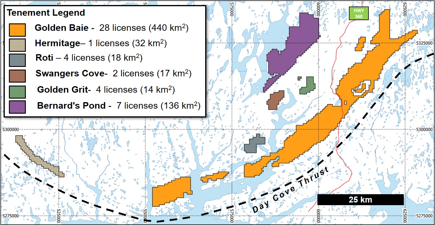 Figure 3 - Location of the Golden Baie Project and claim blocks
Golden Baie Geology
The Golden Baie Project is in the Exploits Subzone of the Dunnage Tectonostratigraphic Zone and is mainly underlain by Ordovician rocks of the Baie d’Espoir Group. The eastern margin of the project straddles the contact between the Dunnage and Gander tectonostratigraphic zones (Figure 4). The two zones are separated by the westward dipping Day Cove Thrust (Figure 5).
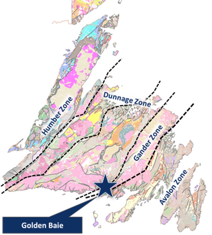 Figure 4 - Geological map of Newfoundland showing major tectonostratigraphic zones and Golden Baie Project location
The Baie d’Espoir Group is host to both volcanogenic base metal sulphide and structurally-controlled styles of mineralization. The gold mineralization is typical of orogenic-type (structurally-controlled) mineralization associated with compressional deformation processes at convergent plate margins in accretionary and collisional orogens.
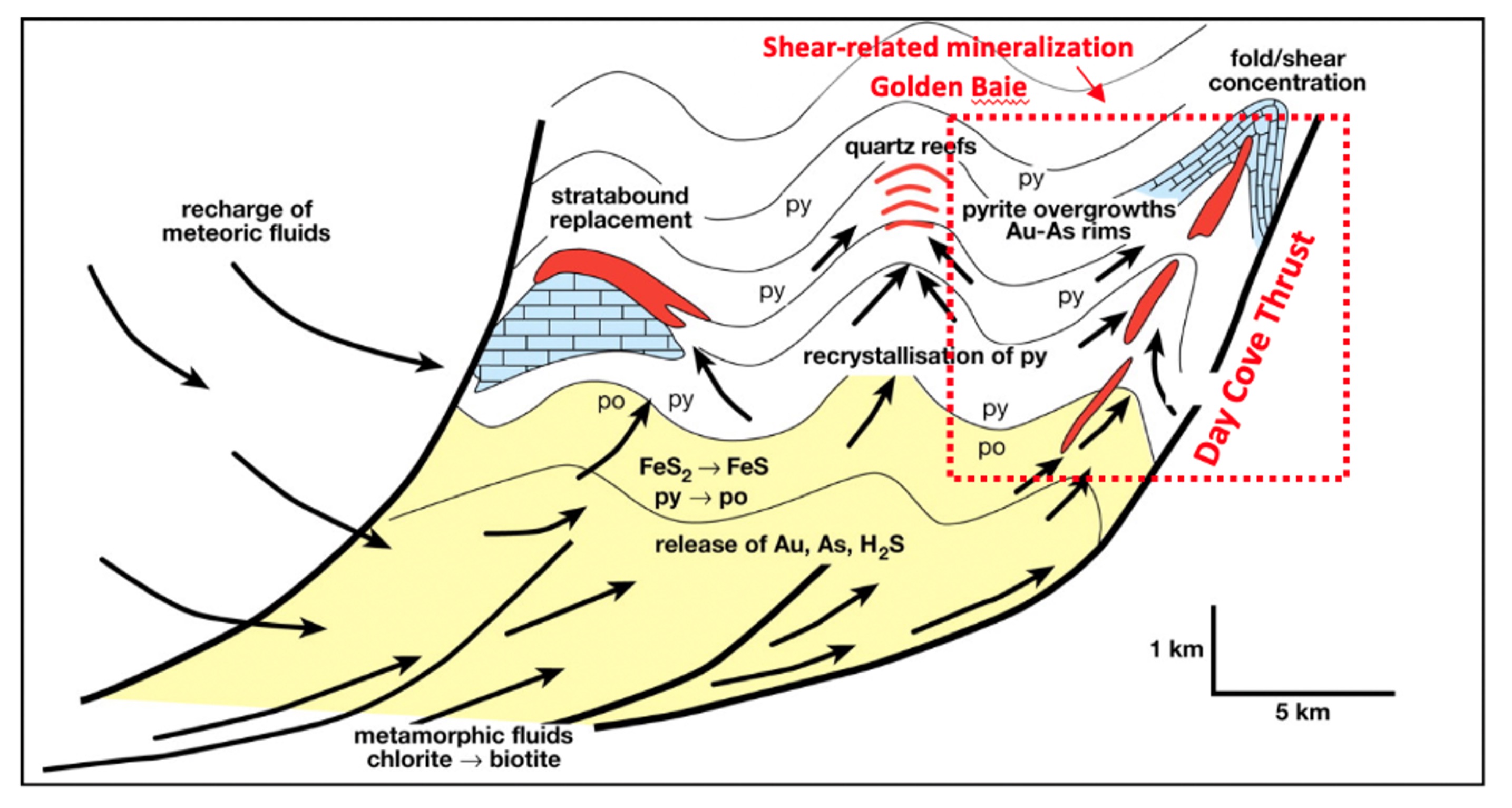 Figure 5 - Generalized model for the genesis of orogenic gold deposits (modified from Large et al., 2007)
The Golden Baie Project covers both highly prospective rocks of the Baie d’Espoir Group which historic exploration and recent prospecting have shown to be a prolific host for gold mineralization, and the crustal-scale fault zone (the Day Cove Thrust) which juxtapose Neoproterozic Gander Zone rocks the with Cambro-Ordovician Dunnage Zone rocks (Figure 6). The tectonic setting, the late Silurian deformation and plutonism, the juxtaposition of Neoproterozoic-aged rocks with younger Dunnage Zone rocks, the presence of structurally-controlled gold mineralization and a pronounced linear-trending mineralized belt (Isle Galet Fm.) which sits in the hanging-wall to and largely parallels the trend of Day Cove Thrust, all indicate that the Golden Baie Project has significant potential to host economic gold deposits.
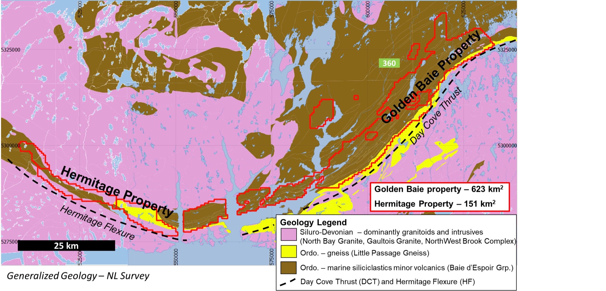 Figure 6 - Generalized geology of the Golden Baie and Hermitage Flexure properties
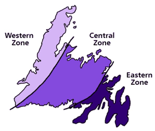 Figure 7 - Newfoundland in the Middle Cambrian (540 million years ago)
The bringing together of ancient oceans and continents has given Newfoundland three geological zones: the Western, Central and Eastern zones. Each of these zones has distinct rock types and geological histories.
About 600 million years ago, North America was part of a much larger continent. Then this continent broke apart. A mid-ocean ridge developed along the break and the Iapetus Ocean began to open. By the Middle Cambrian (540 million years ago), the Western Zone lay on the eastern edge of ancient North America, a continent we now call Laurentia.
In the Middle Cambrian two ancient continents, Laurentia and Gondwana, were separated by the Iapetus Ocean. The Western Zone of Newfoundland lay on the eastern edge of Laurentia while the Eastern Zone was part of Gondwana.
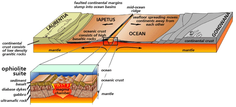 Figure 8 - Newfoundland in the Middle CambrianOpening of the Iapetus Ocean and the formation of a mid-ocean ridge 540 million years ago during the Middle Cambrian period. From Stephen Colman-Sadd and Susan A. Scott, Newfoundland and Labrador: Traveller's Guide to the Geology (St. John's: Government of Newfoundland and Labrador, 1994).
Then convection currents shifted and subduction began. By Early Ordovician time (about 490 million years ago), volcanic island arcs had grown above the subduction zones, as the floor of the Iapetus Ocean sank back into the mantle. Today, the remains of these island arcs are preserved in the volcanic and intrusive rocks of the Central Zone.
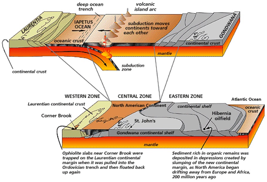 Figure 9 - Newfoundland 490 Million Years Ago and TodayClosing of the Iapetus Ocean and collision of ancient continents which took place 490 million years ago in the Early Ordovician. From Stephen Colman-Sadd and Susan A. Scott, Newfoundland and Labrador: Traveller's Guide to the Geology (St. John's: Government of Newfoundland and Labrador, 1994).
Subduction of the Iapetus Ocean caused the slow collision of Laurentia and Gondwana, forming a huge new continent. Across the middle of the continent, where the Iapetus Ocean had once been, there was a mountain range, and half way along this lay what is now Newfoundland. About 200 million years ago, this continent broke apart to form the present Atlantic Ocean; the fracture, however, occurred slightly to the east of the earlier collision line, leaving fragments of Gondwana still attached to Laurentia. The Eastern Zone of Newfoundland is one of these fragments.
Subduction of the Iapetus Ocean floor slowly pulled Laurentia toward another continent, Gondwana, which lay to the east. As the continents converged, pieces of ocean crust and the underlying mantle were pushed onto the continental margin of Laurentia about 470 million years ago.
